Sign Shapes and Colours
Signs, signals and pavement markings help indicate the rules of the road designed for the safe movement of vehicles, pedestrians and cyclists. As a driver, you’re required to know them. The shapes of signs enable you to identify them in darkness, fading light, fog, rain or snow.

Fluorescent yellow-green pentagon indicates school area. Drive cautiously. Children could be crossing the street.

Diamond warns you of possible dangerous conditions, either on or near the roadway (e.g., a sharp curve, turn, side road, intersection, narrow bridge). Slow down to keepfull control of your vehicle.

Octagon is used only for stop signs. Always come to a complete stop

Triangle with the tip pointing down means you must yield the right-of-way. Slow down and, if necessary, stop.

Triangle with each tip cut off indicates a slow-moving vehicle.

Crossbuck indicates a railway crossing. Always slow down and look both ways for trains before crossing the tracks. You must yield the right-of-way to trains.

Square or Rectangular signs regulate traffic and direct the driver.

Note: Times listed on signs follow the 24-hour clock so that:
0:00 = midnight
1 a.m. to noon remains the same.
13:00 = 1 p.m.
14:00 = 2 p.m.
15:00 = 3 p.m.
16:00 = 4 p.m.
17:00 = 5 p.m.
18:00 = 6 p.m.
19:00 = 7 p.m.
20:00 = 8 p.m.
21:00 = 9 p.m.
22:00 = 10 p.m.
23:00 = 11 p.m.
Warning Signs
These signs warn of possible dangerous conditions immediately ahead.

Very sharp right turn ahead

Divided highway begins ahead

Sharp right curve, maximum recommended speed 40 km/h

Divided highway ends ahead

Pedestrian crosswalk ahead

Two-way traffic ahead

Winding road ahead

Right lane ends ahead

Road ends, exit right or left

Left lane ends ahead

Bump ahead

Merging roadways ahead

Steep hill ahead

Hidden intersection ahead

Bridge ices

School area indicated by fluorescent yellow-green pentagon

Narrow bridge ahead

Hazard marker showing an obstruction

Stop ahead

Low structure clearance 4.1 metres

Traffic signals ahead

Right curve ahead

Playground ahead

School crosswalk ahead

Deer crossing area ahead

Railway crossing advance warning, track position indicates the angle the railway tracks cross the road

Road slippery when wet

Traffic island ahead

Roundabout ahead

Pavement ends

Maximum recommended speed on exit 40 km/h

Maximum speed limit change ahead

Reserved Bus Lane ahead

Reserved Lane located in curb lane of cross-street, if turning right, enter the second lane from the curb

Reserved Lane located in median lane of cross-street, if turning right, enter the curb lane

Prepare to stop. When the amber lights on the sign are flashing, approaching drivers should be prepared to stop, as the traffic signal ahead is red or about to turn red.

Railway Crossing Sign: This railway crossing sign is equipped with warning lights and bells. When the lights are flashing and the bells are ringing, be prepared to stop as they warn you of an approaching train.
The number on the square sign under the railway crossing sign indicates the number of train tracks. Refer to the Railway Crossing section for further information.
Construction and Maintenance Signs
These signs warn you of road construction and maintenance areas ahead. Slow down to a safe speed. At some locations maximum speed limits are posted.
Drivers must watch for and obey the instructions of flag persons

Designated construction zone: speed fines double

Construction zone ends

Maximum speed 40 km/h when meeting traffic

Detour ahead

Overhead wires

Barricade ahead

Flying stones

Part of roadway has been removed

Construction area

Trucks entering on the right

Flagperson ahead

Road work
Bump ahead

Pavement edge drop-off
Regulatory Signs
These signs regulate your driving, informing you about speed limits, permitted turns, stopping and parking rules.

No turns allowed

No U-turn allowed

No right turn

All traffic must turn right

No left turn

No trucks allowed

Do not enter

Truck route

No right turn on red signal

All traffic must turn left

Keep right of this sign

No right turn during the times shown

Reduced speed school zone

Reduced speed school zone (restricted hours)

Maximum speed 60 km/h ahead

Maximum speed 90 km/h

Reduced speed school zone ends

Parking permitted as indicated

Parking is prohibited

Parking for disabled persons only

Do not stop to wait

Snow Route: No stopping during a declared “snow emergency”

Pedestrian Corridor

Do not enter: Except buses and cyclists

Pedestrian Crosswalk

School Crosswalk

Two-way traffic

Stop here for red traffic signal

Do not pass

This lane of traffic must turn right during the times shown, except buses and cyclists

Passing permitted

This lane of traffic must turn left

Overhead mounted sign indicating that the curb lane is reserved for buses and cyclists during the times shown

This lane of traffic may go through or turn right only

Slower traffic keep right

Through traffic is not permitted to use this lane. Traffic, having entered this lane, must turn left at the next intersecting private approach or public street.

Keep right except to pass

One Way: Proceed in direction of arrow only

Speed fines are doubled in designated construction zones

Buses only
Guide and Information Signs
These tell you where you are, what road you’re on or how to get to certain places. There are many different types of these signs, such as service signs, location signs, route marker information and distance signs. They vary in size and colour

Eastbound TransCanada Highway

Hospital

“A” indicates an alternative route that will return to the route you’re on

Camping site

Westbound Provincial Trunk Highway

Travel Information

Southbound Provincial Road

Picnic site

Northbound City Route turns right

Access for disabled persons

Cul-de-sac (Dead end with turnaround)

Stop for school bus when signals flashing

Airport with scheduled service
Stop Signs
At a stop sign, you must come to a complete stop at the appropriate places. Before proceeding from a stopped position, you must check and yield the right-of-way to pedestrians wanting to cross the street. When pedestrians are clear, you may then slowly move forward for a better view of traffic and, when safe to do so, you may then proceed to turn or cross the street.
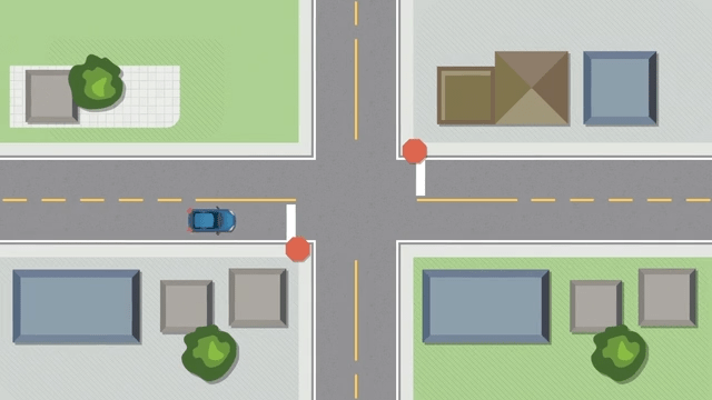
Four-Way Stop Signs
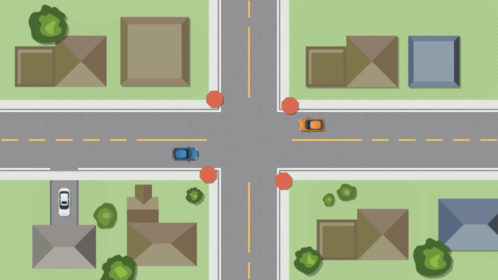
At an intersection controlled by a four-way stop sign, the vehicle that stops first should go first. After stopping and yielding to any pedestrians wanting to cross, roll slowly forward to show your intent to proceed. If two or more vehicles stop at the same time, the vehicle on the left should yield to the vehicle on the right.
Yield Right-of-Way Signs
A yield sign means slow down as you near an intersection. Check for pedestrians and traffic. If there’s traffic or pedestrians, stop and yield right-of-way. Yield signs are usually located where a lane or road merges with another lane or road. You must slow down and be prepared to stop. Be careful when checking for traffic so that you don’t run into the car ahead of you.
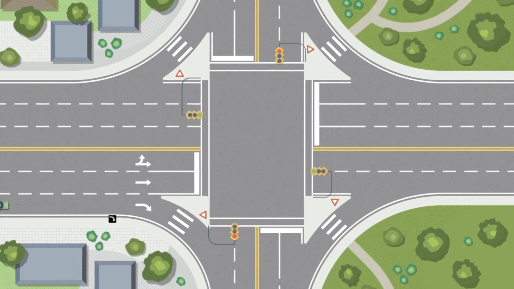
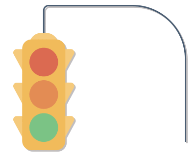
Traffic Control Signals
Red — Stop in front of the marked crosswalk or, if there’s no marked crosswalk, before the sidewalk out of the way of pedestrians and vehicles. Unless a sign shows otherwise or vehicle/pedestrian traffic does not permit, you may, after stopping completely, turn right. You may also turn right or left from a one-way street to another one-way street.
Amber — An amber light is a warning that the light is going to turn red. Slow down and stop — never accelerate to “make the light.” If you’re already in the intersection when the light turns amber, continue through.
Green — You may proceed, but you must yield the right-of-way to pedestrians in the crosswalk and to other vehicles already in the intersection. To turn left, you may enter the intersection on a green light, but you must yield to pedestrians and oncoming traffic. You may have to complete the turn during an amber or red light.
Flashing Red — Come to a complete stop, proceeding only when safe.
Flashing Amber — Slow down and be prepared to stop. You must yield the right-of-way to pedestrians.
Amber Arrow — A steady amber arrow may be shown after a green arrow. The amber arrow is a warning that oncoming traffic may next receive a green signal. Slow down and stop. If you’re already in the intersection when the amber signal appears, continue and complete your turn.
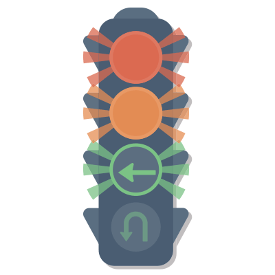
Green Arrow — You may proceed only in the direction of the arrow, either steady or flashing, providing you’re in the proper lane.
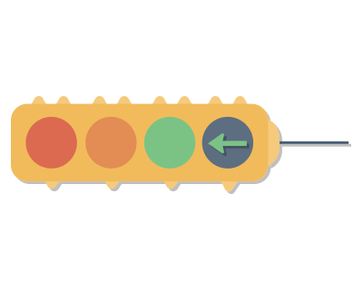
Flashing Green Left-Arrow — You may proceed only to make a left turn, unless facing another signal that indicates other movements are allowed. (Flashing leftarrows may be shown together with steady red, amber or green lights.)
Green U-Turn Arrow — You may proceed to make a U-turn after yielding to pedestrians and other vehicles already in the intersection.
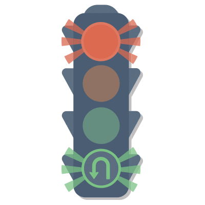
Green Left-Arrow with Red Light — When a green left-arrow is shown with a red light together you may proceed and make a left turn only. It’s illegal to make a right turn at an intersection when a green left-arrow is shown with a red light, even if there’s no sign indicating a right turn is prohibited on a red light. Under no circumstances are you allowed to turn right or drive straight through when a green left-arrow is illuminated with a red light. If a green left-arrow is illuminated alone (the red light is not on) you may turn right if it’s safe to do so and no sign prohibits it.
Transit Priority Signal
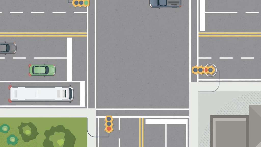
A signal light with a white vertical bar on a black background allows transit buses to proceed before other traffic. Only public-transit vehicles (buses) may proceed when the Transit Priority Signal is shown, while other vehicles must remain stopped. (The Transit Priority signal is always accompanied by a steady red light).
Pavement Markings
A solid line on the left of your lane means you must not pass or change lanes. A broken line means you may pass or change lanes if safe from both front and rear to do so. It’s permissible to turn left over a single or double solid line onto a private road or driveway.
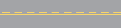
Yellow lines
Yellow lines indicate traffic moving in opposite directions.

Broken line — Passing is permitted.
Solid and broken line together — Passing is not permitted if the solid line is on your side of the highway.

Double solid line — Passing is prohibited for traffic going either way.
White lines
White lines indicate traffic moving in the same direction.
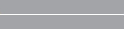
Solid line — Lane changing is not permitted.
Broken line — Lane changing is permitted.

Stop line — You must stop before this line.
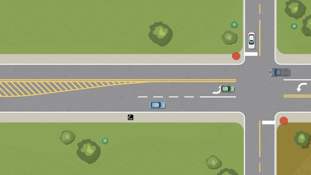
No traffic is permitted within Painted Left-Turn Islands, which are commonly used in rural areas to channel traffic into turning lanes.
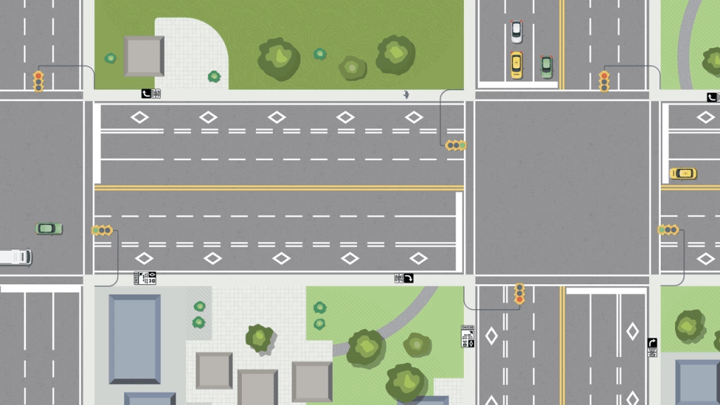
Reserved Lanes

In some urban centres, to improve the safety and flow of designated vehicles, certain traffic lanes have been reserved for specific uses. Traffic signs identify the vehicles or actions that the lanes are reserved for. The reserved lanes are marked by double broken lines and white diamond patterns. The following are some examples of how reserved lanes are used:
1. With-Flow Reserved Lane
A curb lane is reserved for use by designated vehicles only. Motorists making right turns are permitted to enter the reserved lane at any point in the block preceding their turn.
Pavement Markings
Double broken white lane lines and diamond symbols designate the reserved lane.
Turning Right onto a Reserved Lane If you’re turning right onto a street with a Diamond Lane in the curb lane, you must turn as close as practicable to the curb and into the first lane. You should then signal, check and change lanes out of the Diamond Lane into the adjacent lane as soon as it’s safe to do so. If you’re driving parallel to a Diamond Lane and need to turn right, you can enter the Diamond Lane but you must turn right at the next intersection. Always be watchful and respect the rights of cyclists using the Diamond Lanes.
Cycling Pavement Markings
1. Bicycle lanes
These on-road painted lanes are intended to provide cyclists with a defined space and help organize the flow of traffic. They’re also a visual sign to motorists that cyclists have a right to the road.
Motor vehicles can occupy space on both sides of the bike lane and are able to cross the lane at any time. Most bike lanes are located to the left of the parking lane and as such require motorists to cross the bike lane when entering or leaving a parking spot. Motorists also must cross the bike lane when turning at an intersection, lane or driveway. Motorists need to be alert for cyclists already in the lane, in particular at intersections.
Cyclists are not limited to the use of a bike lane when it’s provided. While the bike lane offers a defined space for cyclists, there are times when they may have to leave the bike lane in order to change lanes, make a turn or leave the roadway. Motorists should always be aware of cyclists on the road and note that the solid line on each side of the lane does not mean the cyclist cannot leave the bike lane.
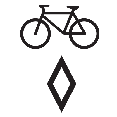
Pavement markings
White lane lines and a diamond symbol with a bicycle designate a bicycle lane.
2. Sharrows
Sharrows are pavement markings painted on a roadway to encourage cyclists and motorists to share the road. They’re generally intended for use on roadways with lanes that are wide enough for side-by-side bicycle and vehicle operation. However, motorists should always pass cyclists at a safe distance and should not assume that the sharrow indicates that they can pass within the travel lane. Depending on the positioning of the cyclist, it may be necessary to change lanes in order to pass safely.
Sharrows don‘t designate a bicycle lane and should not be treated as such.While some cyclists will ride down the center of the arrow, in many locations, the sharrow marking simply indicates cyclists and motorists are to share the lane and is not an indication of where a cyclist rides within the lane.
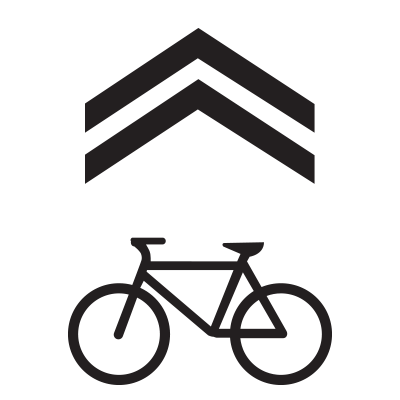
Pavement markings
A chevron and bicycle symbol designate a sharrow lane.
